
A few weeks ago, there was augmenting the new with the old – this week; the more likely trend of overlaying the old with the new. The installation of a QR code, made of stone, on a 150 year old building.
As computing moves into the environment, and becomes more invisible, how long will it be before QR codes are considered the equivalent of a modern day 50kg CRT monitor? and at some point will the eventual relic-code itself move from being a perceived “eye-sore”, to adding to the history of the building?
It’s been 12 months since I started my PhD, and it’s probably a good time to take stock and figure out exactly where I’m taking things. I wrote an original abstract after our initial visit and talks to park rangers, and have had it stuck to my wall since. Today, finally, it bugged me – so, I thought it was time to present to you a new one; followed by some of the major changes in the stances I’m taking.
So… what’s changed?
Context awareness
The major difference is the change from “location based” to “context aware”. Whilst location is still a large part of the research, location is just one variable in the broader notion of context – location isn’t enough when it comes to understanding the knowledge people have about somewhere; the meaning people attach to the raw “space” – a GPS coordinate- provides far greater meaning to the knowledge that is used and created there.
This notion of a raw location augmented with social meaning is referred to as “place”, and it is this socially constructed notion of location – not an x,y coordinate – that I will use as the core meaning of the term “context”.
Facilitation
Following from the idea of “social construction”, I’ve made it a point to explicitly state that whatever I design/build will not aim to interpret and provide meaning itself, but will consist of services and interfaces that allow people to construct their own interpretations of data, and to communicate it with others. The idea of knowledge as a social object is important here, as is literature around communities of practice and situated cognition. It’s more meaningful if you let people discover things for themselves.
Removing tacit
I’ve taken the word “tacit” out of the abstract – not because I won’t be dealing with it, but because I’ve wondered if it’s too limiting. The idea of facilitating knowledge discovery and creation is still directly related to tacit knowledge – the kind that cannot be easily gained or taught – and I feel that this implied direction is enough without explicitly stating I’m going to solve the world of it’s tacit knowledge problems.
The social life of knowledge
I’ve also deliberately used words to describe the cycle knowledge goes through in it’s social contexts – retention, generation, and communication. The system should facilitate all three activities equally, and with as seamless a transition between them as possible.
And next…
This refocuses the project somewhat – now, to actually make something.
On Friday I gave a presentation in one of the last sessions at OZCHI in Brisbane, Australia. It covered some familiar topics that I’ve presented on before, but also contained new elements of what location as context might mean.
The paper is available in the OZCHI proceedings, and I’ll upload a version here once I get access to a decent internet connection.
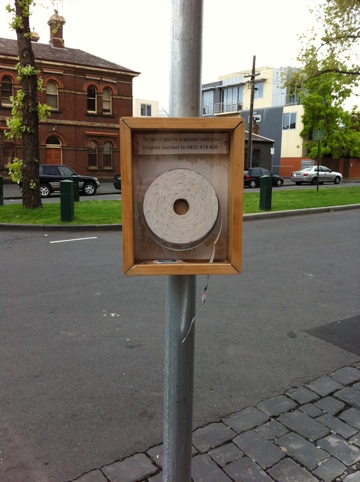
There seems to be a recent trend towards augmenting new services with nostalgic versions from less tech-y times – the above taken on an inner city suburban street in Melbourne; it invites people to take a token and SMS the code. Just because you can pull out the technology, doesn’t mean you should.
A few weeks ago Intel CTO Justin Rattner gave a keynote speech on Intel’s vision for context-awareness. The opening video is a little cheesy, but it shows just how important a problem the notion of context has become to technology (and the companies most involved in it’s creation). Most of the examples shown are around intelligent recommendations – mobile phones that pick’n’mix information from various applications running inside them. Scenarios show applications making food and sightseeing suggestions, and reminding you to bring an umbrella because it might rain soon.
The one that struck me the most was a remote control that built user profiles from the way you press it’s buttons.
Still, I find this vision lacking something. It’s all about what can be computationally sensed. What about context – as much of it is – that is created dynamically, fleetingly, and between people?
The video is worth a watch:
There’s so much happening in the “location” space it’s easy to discount it as a buzzword. It doesn’t help that the phrase “Location Based Service” gets misused in ways that severely limit it’s scope – I’m looking at you, plethora of check-in apps.
But, location and, more so, context-awareness are the real deal, and as our understandings of them evolve we’re going to see more formal structures and guidelines for their use – particularly for developers and service designers.
The OpenGEO group are leading the way in developing standards for use in location services. By providing a set of common and desirable system attributes they not only provide guidelines for new applications and services, but also give us a criteria to assess existing ones. If you call yourself a location-based-service, you’re probably doing much of what they suggest anyway. However, it’s still worth checking out. Just in case.
Once you’ve got your head around those and are interested in getting in on the ground floor of a similar but complimentary initiative, you might want to check out the recently launched W3C POI Working Group.
From their charter:
The objective of the POI WG is to develop a Recommendation that defines a POI data format that allows digital content publishers to effectively describe and efficiently serve points of interest data.
That is, they’re working on describing exactly how points should be defined, and how they could be transmitted.
In other news…
There appeared to be lots of interesting stuff presented at the International Symposium on Mixed and Augmented Reality conference in Korea, and RMIT’s own Matthew Kwan has developed geoSMS: a standard for sending your location via SMS.
Next: a quick breather after conference paper submissions before starting on some interesting new work.
The idea of context-awareness has been gaining a lot of attention recently, and it’s driven largely by the fact that the required technology has become affordable and reliable enough to bother. “Location” though, as a raw GPS coordinate, is not enough. Here’s my take on what’s after this sensor-based revolution, taken from a recently submitted conference paper: Continue reading »
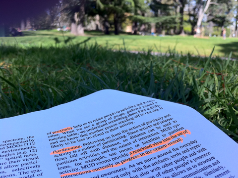 The first weekend of sunshine has brought everyone and their frisbee out, and I’m enjoying the best of both worlds armed with a highlighter and a backpack for a pillow. What better place to think about context-awareness in parks than in a park?
I’m currently knee-deep in another conference paper – this one to be submitted to ICA Conference in Paris, 2011. If accepted I’ll be heading there in July. That’s the bread-stick of motivation currently being dangled in front of my buret-adorned and stripey shirted self.
To be honest, even without the Eiffel Tower looming, I’d still be reading and writing about this right now as context-awareness has captured my imagination. I’m working towards a first draft of the paper today and over the weekend, but I thought I’d post the introduction here for feedback on its direction.
Visualisations are a powerful tool when it comes to helping us make sense of data. Exploiting our perceptual abilities is a very efficient means of finding novel and interesting relationships and patterns in data that we simply don’t notice when staring at the raw numbers.
The following documentary discusses data visualisation and why it is becoming extremely important: Data is now free and ubiquitous; the skills, tools and insight required to make sense of that data is now the rarer commodity.
