Digital territories
If you haven’t seen the news this week, there have been increasingly violent protests in Beijing over a territorial dispute between China and Japan about a set of small islands in the East China Sea. The two countries have a number of complicated historical tensions: the Japanese invaded and occupied China in 1931, and the anniversary of the invasion is in this coming week. I won’t go into detail on that, but you can read more about that piece of history, in the context of the current dispute, in this guardian editorial.
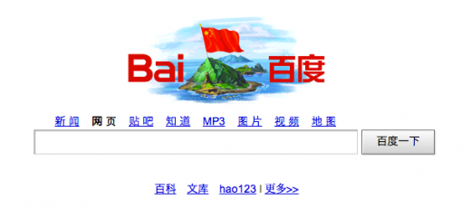
Whilst the dispute over the islands will continue to play out on the political and diplomatic level, what I found interesting were the territorial claims happening in digital space. The picture above was a ‘doodle’ on Chinese search site Baidu. Popluarised by Google, doodles on the American search site have generally been used to mark historically significant events, anniversaries, or tap into some timely global sentiment (as evidenced through the recent olympics).
However, Baidu’s doodle is asserting a territorial claim on real, tangible pieces of land. This isn’t the first time technology has been used as a tool in asserting views of geographical borders – google maps and google earth famously show different borders depending on the language you view them in. Viewing Tibet or Taiwan from a Chinese-language version of these products would tell a different story than viewing the US-English version, for instance.
In addition to the ‘doodle’ though, Baidu have set up a site that allows virtual flags to be placed on the archipelago, where over 2 million people have staked their claim on the land. All borders are, of course, constructed out of political, economic and social interactions; they are constantly shifting and negotiated. However, this is the first example i’ve come across where a country/organisation has essentially been able to crowd-source territory.
Maps and cartographic representations as technologies have been used for centuries to define borders, regions and territories. With this recent dispute, cartography finds itself in a new ‘landscape’ – one that is defined by the same real-time, socially driven technologies that are disrupting so many other industries and disciplines.
No related posts.
Search
Geoplaced
This is a notebook exploring the gaps between geography, sociology, technology, science fiction and things between.
I used to write about my PhD here, which I finished in July 2013. You can download a PDF or order a print-on-demand copy of my PhD thesis.
Themes
- art (1)
- Augmented Reality (2)
- Brain Dump (17)
- Conducting a PhD (13)
- Context (6)
- essay-a-fortnight (2)
- fiction (1)
- Government (1)
- How to: Get a PhD (5)
- inspiration (4)
- Knowledge (15)
- Location (19)
- Methods (6)
- Mobile (2)
- Parks Vic (17)
- Place/Space (5)
- Research Questions (11)
- Technology (3)
- travel (1)
- ubicomp (7)
- Uncategorized (11)
- Visualisation (10)

